1918-1929: Popular maps
After the end of the First World War, Ordnance Survey took a fresh look at itself with the help of market research. For the first time it asked the public what they wanted from Ordnance Survey’s maps. From the results of this market research came the 1-inch Popular Edition.
The Popular Edition was laid out in 146 sheets on the Cassini projection. Most sheets covered an area of 27 miles × 18 miles with variations around the coasts. There was some overlapping of sheets in places, similar in nature to those of the 1-inch Third Edition (Large Sheet Series).
Copperplates from the 1-inch Third Edition (Small Sheet Series) sheets were used as the base material for the Popular Edition sheets, incorporating major revision. The colour scheme was altered, the main improvements reflecting the increasing use of motorised transport. ‘Good roads fit for fast traffic’ were marked in red, ‘good roads fit for ordinary traffic’ in yellow, ‘indifferent or winding roads’ in broken yellow, and ‘bad roads’ uncoloured.
 Figure 1 1-inch Popular Edition sheet 104 (pub. Jun 1919) |
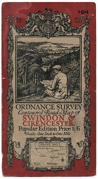 Figure 2 1-inch Popular Edition sheet 104 (c.1920) |
The first 31 sheets of the Popular Edition were published in June 1919, covering much of Central Southern and South-western England. The original cover artwork was designed by Ellis Martin - an engraved black design printed on buff card, with orange-red sheet title. The picture is of a cyclist sitting on a hillside perusing a map. The covers for mounted & folded or dissected sheets were in two pieces, at first hinged - and then later stuck flat - to the rear of two panels of the folded map. (Figure 1). The covers for paper folded sheets were in one piece, hinged on the left-hand side. The price of each sheet was: 1s 6d mounted & folded, 2s 6d dissected.
By December 1919 a further seven sheets had been published, to cover Berkshire, Oxfordshire and parts of Warwickshire, Northamptonshire and Bedfordshire. By this time, it was found that the original cover design appeared to become soiled too quickly, and it was decided to add a red border to the cover. (Figure 2). Thus, very few sheets will have been issued in buff-coloured covers.
From late January 1920, the price of Popular Edition sheets increased: 1s 6d paper folded, 2s 6d mounted & folded, 3s 6d dissected.
Publication progressed steadily eastwards and northwards over the next 6½ years. The series was completed with the publication of sheet 1 River Tweed in the summer of 1926.
The price of paper folded sheets was increased to 1s 9d around 1929.
1930-1941: The road to war
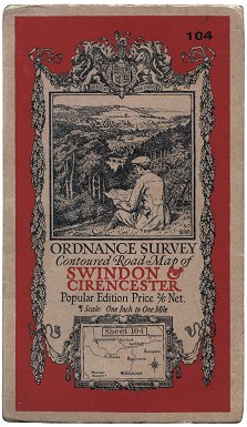 Figure 3 1-inch Popular Edition cover (c.1931) |
 Figure 4 1-inch Popular Edition ‘Bender-fold’ cover (c.1939) |
Around 1931, the size of the covers on the Popular Edition (and other maps) was increased to give greater protection to the maps within. The red colouring, however, was not extended to the edges, thus leaving an uncoloured border. (Figure 3)
The price of dissected Popular Edition sheets was increased to four shillings in 1934.
The ‘Bender fold’ - which allowed any part of the map to be viewed without opening the sheet fully - was introduced to some sheets of the Popular Edition from 1939. The covers for these sheets were in one piece, hinged at the top instead of at the side, and featured red colouring right to the edges. (Figure 4)
The introduction of the Transverse Mercator projection - and, later, the metric grid - led to the initiation of work on the 1-inch New Popular Edition. This spelled the beginning of the end for both the Popular Edition and the Fifth Edition. With the disruption caused by the Second World War, however, the Popular and Fifth Edition maps were used as the base material for the 1-inch War Revisions from 1940.
The last known printing of a coloured Popular Edition sheet was printing ‘M39.R38.3041.L.R.’ of sheet 135 Hastings, which was carried out in 1941. Thereafter Ordnance Survey concentrated on other priorities such as war work and new map series. Unrevised Outline printings of some Popular Edition sheets continued until 1944, however.
Page last updated: 14 April 2012