1940-1941: A military rush-job
After the Dunkirk Evacuation at the end of May 1940, the threat of invasion was now very real. The Second World War had come to the Home Front. The military turned to their maps of Great Britain - produced by the Ordnance Survey - to find them woefully outdated and inadequate. Ordnance Survey immediately dropped work on the 1-inch New Popular Edition and began an intensive programme of updating the military’s sheets.
Before 1940, the military’s maps of England & Wales had the unmemorable series title ‘GSGS 3907’, and of Scotland ‘GSGS 3908’. These were based on the sheet lines and mapping of the 1-inch Popular Edition and 1-inch Popular Edition of Scotland, although the military and civilian series developed separately.
The ‘War Revision 1940’ used the latest civilian 1-inch sheets available in the correct size, with the addition of a military grid overprint and - if there was time - a few important revisions. Once produced, these sheets took on the ‘GSGS 3907’ or ‘GSGS 3908’ title. Eleven sheets in the south-west of England used the 1-inch Fifth Edition sheet lines and mapping, although elsewhere 1-inch Popular Edition or 1-inch Popular Edition of Scotland sheet lines and mapping were used. The first 1-inch War Revision sheets were issued in the Summer of 1940.
Ordnance Survey’s priority was England & Wales, because the threat of invasion was felt to be greater in the southern part of Great Britain. The first Scottish War Revision sheets were not issued until June 1941.
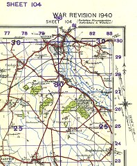 Figure 1 Detail from 1-inch War Revision (GSGS 3907) Sheet 104, print 20,000/41. |
Naturally, the War Revision maps were issued for military use only upon their initial production. They were issued as flat cloth-backed or paper sheets only. (Figure 1)
The reference grid printed on the maps is the War Office’s Cassini Grid, also known as the ‘WOFO’ or ‘War Office False Origin’ grid. This appears at an angle to the sheet edges because of the fact that the projection origins of the sheet lines and the grid differ by some 1½° of longitude.
The Germans carried out two nights of bombing over Southampton, on 30 November and 1 December 1940, targeting the Ordnance Survey’s headquarters. This led to the destruction of several map drawings in preparation, and also some stocks of printed maps. The printing plates for the War Revision, however, survived and were used to continue printing the maps.
Having met the immediate needs (or at least having covered most of England & Wales in 1-inch War Revision), work was begun on producing a ‘Second War Revision’, upon which could be spent more time making sure all the necessary revisions were incorporated. This also allowed more sheets - although based on 1-inch Popular Edition sheet lines - to use mapping from the 1-inch Fifth Edition where this existed. The ‘Second War Revision’ sheets were issued from early 1941 onwards.
1942-1948: Publication
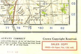 Figure 2 Detail from 1-inch Second War Revision 1940 (GSGS 3907) Sheet 104, print 20,000/1/43 LR |
In late summer 1942, with publication of the 1-inch New Popular Edition having been blocked by the War Office, and with civilian map stocks dwindling, Ordnance Survey managed to persuade the WO to allow publication of the War Revision sheets for civilian consumption. These were then issued, from early 1943, with ‘Sales Copy’ stickers - apparently to prevent military personnel from selling their free-issue maps to the general public! (Figure 2)
A lot of printing work from around 1942 onwards was farmed out to other companies, to allow faster printing of sheets for both civilian and military issue.
The 1-inch War Revisions remained in print until their replacement sheets - in either the 1-inch New Popular Edition, the 1-inch Popular Edition of Scotland (Post-war) or the military’s new 1-inch series (‘GSGS 4620’) - were published.
Page last updated: 14 April 2012