1978-1984: A photographic pioneer
The Routemaster series, launched in 1978, covered Great Britain in 9 sheets. The Routemasters’ mapping was constituted from the ‘¼-inch’ Fifth Series, which it replaced.
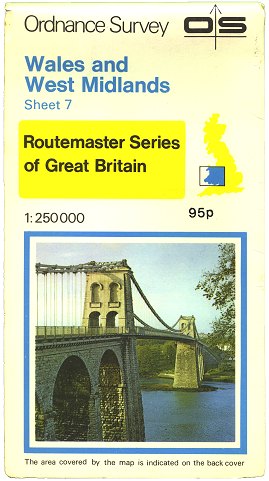 Figure 1 Routemaster Sheet 7 Edition A (1978) |
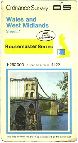 Figure 2 Routemaster Sheet 7 Edition D (1982) |
The Routemasters were the first Ordnance Survey maps with full-colour photographs printed on their covers. (Figure 1)
Around 1982, the colour of main roads on the Routemaster maps was changed from dark red to stippled red, and primary destinations were highlighted in stippled green. Coincident with this was a slight redesign of the cover. (Figure 2)
1985-1993: Modernisation
 Figure 3 Routemaster Sheet 7 Edition J (1985) |
In 1985, the Routemasters’ mapping was re-lettered in a more modern sans-serif font. At the same time, the covers were redesigned again, to complement the other cover designs of the time. (Figure 3)
Routemaster maps continued to be revised until 1991, before being replaced by the Travelmaster series in 1993.
Page last updated: 14 April 2012