1971-1981: Doing things by half
In the mid/late 1960s, Ordnance Survey made the decision to complete the move to entirely metric mapping. After several trials of many different formats, a scale of 1:50 000 was chosen in the autumn of 1971. The sheet lines of the series were laid out to map Great Britain in 204 sheets, each map covering an area of 40km × 40km.
The first batch of sheets - nos. 102-204, covering the southern part of Great Britain - were all published on 7 March 1974. All but three of these sheets were published as ‘1:50 000 First Series’ maps, intended to be a short-term interim measure and created by photographically enlarging the latest editions of the 1-inch Seventh Series and incorporating minor revisions. Several colour changes were also introduced: motorways were changed from red to light cyan, built-up areas from grey to stippled orange, and several other less significant changes were made.
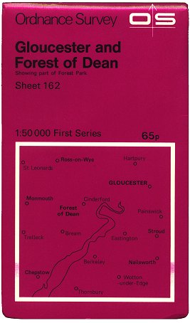 Figure 1 1:50 000 First Series cover (1974) |
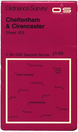 Figure 2 1:50 000 Second Series cover (c.1978) |
 Figure 3 1:50 000 First Series cover (c.1980) |
 Figure 4 1:50 000 Second Series cover (c.1981) |
The 1:50 000’s cover design was left virtually unchanged from that of its predecessor, the 1-inch Seventh Series. The only significant changes, in fact, were the new colour (rodamine red, more commonly referred to as ‘magenta’) and the increase in size to 227mm (c. 9in) tall. (Figure 1)
Three of the first batch of sheets (115 Snowdon, 176 West London and 177 East London) bypassed the ‘interim’ First Series stage and went straight to ‘Second Series’. (Figure 2). This involved the complete redrawing of each sheet to an improved specification but identical colour scheme.
Sheets 1-101 - covering the northern part of Great Britain - were published on 20 February 1976. 53 of these were ‘First Series’, with 48 being ‘Second Series’ sheets from the outset.
In 1977 the plan to re-publish all First Series sheets fully redrawn to Second Series specification was begun in earnest. The first of the redrawn sheets to be published was sheet 107 Kingston-upon-Hull in June 1977.
The 1:50 000 family was rebranded the ‘Landranger’ series during the Winter of 1979/80, meaning there was no longer any distinction on the covers between First or Second Series sheets within. (Figures 3, 4)
The colour scheme for the 1:50 000 Landranger mapping was tweaked in 1981, the main alterations being to change main roads from red to dark magenta and motorways from light to dark cyan. Each sheet was altered at its next revision. At this time the civilian and military editions of the 1:50 000 maps became synchronised, and detailed print codes began to appear at the bottom of the legend panel on civilian-issue printings of Landranger sheets. These were in the format “17000/9/81/810535 S” - indicating 17,000 copies, printed in September 1981 (print job number 810535) at Southampton.
An eighties integral interlude
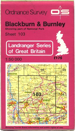 Figure 5 Landranger integral cover (c.1980) |
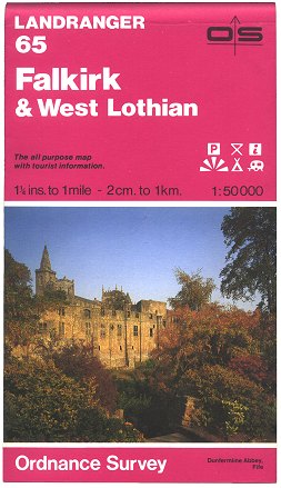 Figure 6 Photographic Landranger integral cover (1984) |
Around 1980, Ordnance Survey started printing its 1:25 000 Pathfinder sheets in such a way that the ‘cover’ and the map were printed on a single sheet of paper, and the ‘cover’ appeared on the outside when the map was folded. Keen to reduce costs, they decided to try the same on the Landranger series. In 1980 the first of these sheets (103 Blackburn & Burnley, First Series edition A/*) was reprinted without revision in so-called ‘integral cover’ format. The design printed on the ‘cover’ was similar to that of the standard card covers apart from a detailed coverage map on the front, derived from 1:625 000 Routeplanner mapping. (Figure 5)
An updated edition of sheet 103 Blackburn & Burnley, redrawn to Second Series specification, was printed in the same integral cover format in December 1981. It would be more than two years before a wider trial for the integral cover design was begun - in March 1984. In this month sheet 103 was again revised and reprinted in integral cover format (slightly amended so that the legend panel appeared on the ‘inside cover’ rather than the innermost panel) along with sheets 197 Chichester & The Downs and 204 Truro & Falmouth. Five more such sheets appeared over the following five months: sheets 40 Loch Shiel, 119 Buxton, Matlock and Dove Dale, 132 North West Norfolk, 150 Worcester and The Malverns and 186 Aldershot and Guildford.
In September/October 1984 three further Landranger sheets were each revised and reprinted with an integral cover: sheets 65 Falkirk & West Lothian, 125 Bala & Lake Vyrnwy and 142 Peterborough. This time though, and for the first time on the Landranger series, these featured a full-colour photograph of a location covered by the map. (Figure 6). This brought the total number of Landranger sheets issued in integral cover format to eleven.
Five of the ‘non-photographic integral cover’ sheets (103, 119, 132, 197 and 204) were reprinted in the same format between September 1985 and March 1986, with only sheet 204 being revised for minor changes. However the integral cover’s days on the Landranger series were numbered: by March 1986 it had been decided as a result of feedback from customers and retailers that the market trial should not be continued or expanded. Between July 1986 and May 1987 the eleven sheets which had been issued in integral covers were reprinted again - this time in the standard format with a separate card cover.
Details of the eighteen printings of Landranger sheets with integral covers can be found here.
1984-1991: Photo finish
 Figure 7 Landranger cover (c.1985) |
 Figure 8 Landranger cover (c.1987) |
The falling cost of printing and increasing emphasis on marketing drove Ordnance Survey to include full-colour photographs on its map covers. These first appeared on the Routemaster Series from 1978, on the Tourist maps of selected areas from 1982, and then on the Outdoor Leisure series from April 1984. As mentioned above, three Landranger sheets received integral photographic covers in Autumn 1984, but very shortly after this an almost identical design also began to be applied to the rest of the series on standard card covers. Each sheet’s cover was illustrated with a photograph of a particular point covered by the map within. (Figure 7). This first photographic cover design for the Landranger was very short-lived, however: it was felt that the ‘Ordnance Survey’ branding was not prominent enough when displayed in a shelf of maps in a shop. Although the extent of its usage is not yet fully documented, it is likely that fewer than 80 of the 204 Landranger sheets were ever issued in the original design of the photographic cover. Details of Landrangers known to have been issued in these covers can be found here.
By March 1985 the first photographic Landranger cover was being replaced by another, similar design, which had more prominent ‘Ordnance Survey’ branding at the top. (Figure 8). Rather than waste printings of previous cover designs, existing stocks of covers were issued on maps before new covers were printed. Thus although the original photographic Landranger cover was only in production for three months or so, it could still be found on ‘new’ maps well into 1986 and quite probably beyond.
The re-drawing of all sheets to Second Series specification was completed in January 1988, with the re-publication of sheet 29 Banff.
From some time during the Summer of 1989, the print codes appearing on the civilian-issue printings of Landranger maps were shortened to omit the number of copies in the print run.
1992-2001: Logo designs and experiments
 Figure 9 Landranger cover (c.1995) |
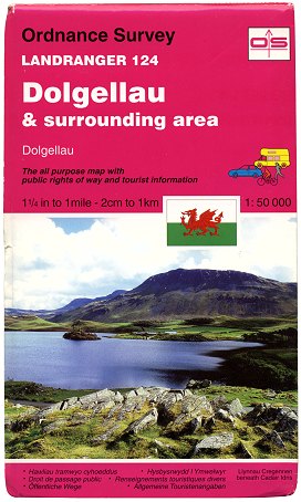 Figure 10 Landranger sheet 124 Edition A2 (pub. Jul 1995) |
 Figure 11 Landranger cover (c.1998) |
A slight cover re-design occurred late in 1992. The Ordnance Survey logo was coloured magenta and placed inside a black-edged box, and new symbols indicating the target user groups were included. (Figure 9). The new design was applied to each sheet at the first available cover reprint, the transition across the entire series taking at least two years to complete.
In July 1995 an experimental special edition of sheet 124 Dolgellau was published with the addition of hill shading. This edition was for a short time adorned with a Welsh flag on the cover and spine (Figure 10). It stayed in print for four years until a new edition of the sheet was published without shading.
The Ordnance Survey logo was redesigned towards the end of 1995. The first published map to carry the new logo was 1:25 000 Explorer sheet 15 Rutland Water published in May 1996. It is believed the first Landranger sheets to receive the new logo on the cover were published two months later - in July 1996. (Figure 11)
An amended specification was introduced from June 1997 at the earliest revision of each sheet (apart from reprints with minor changes). The new specification included the addition of a pink diamond symbol for Long Distance Paths, a bicycle symbol for selected cycle routes and bold purple outlining marking National Trust and Forestry Commission land (replacing the thin pink outline for National Trust land). New editions with the amended specification were published until August 2001, with the specification being tweaked as publication progressed.
Interlude: Subtle changes on Landranger covers, 1996-2002
In common with the 1:25 000 Explorer series, the Landranger covers underwent several subtle changes between 1996 and 2002. The pictures below detail the main stages of change and their approximate production dates.
 July 1996 - Early 1999 The first design with the new Ordnance Survey logo. |  Early - Mid 1999 The Ordnance Survey logo gains a ® symbol. |  Mid 1999 - Mid 2000 The ‘Landranger’ name also gains a ® symbol. |  Mid 2000 - Early 2002 A website address is added and the OS logo shrinks. |
2002-2008: New spec, fresh styling
 Figure 12 Landranger cover (2002) |
 Figure 13 Landranger ‘Active’ (2009) |
The new finalised specification for the Landranger series was introduced across the entire series during 2002. Changes included marking primary routes in green instead of dark magenta, a clearer green dot symbol for cycle routes, a new symbol for ‘Light rapid transit system’ and new tourist symbols ‘Garden’, ‘Golf Course’, ‘Nature Reserve’, ‘Park & Ride’, ‘Visitor Centre’ and ‘Walks/trails’. The opportunity was taken at the same time for a full-scale rebrand of the Landranger series. The cover was completely re-designed, with silver flashes alongside the familiar magenta colour, first appearing in March 2002. (Figure 12). This design also became the basis for the ‘2002 house style’, later to be applied to other Ordnance Survey map series. Publication of all sheets in the 2002 specification was completed by September of the same year.
The introduction of the 2002 Landranger specification coincided with a de-synchronisation between military and civilian editions of the maps. Therefore a print code appearing on a civilian edition of the map no longer necessarily represented an accurate date of printing for that particular map.
Ordnance Survey leisure maps had been sold in laminated form by other companies for at least 10 years previously, but in 2007 25 Landranger sheets were selected to have laminated versions published directly by OS - dubbed ‘Active Map’ editions. (Figure 13). These were first published in November 2007 and are kept updated alongside their standard-format counterparts.
Cycle route symbols used on Landranger mapping were changed slightly in the early part of 2008, with each sheet being updated at its next revision or reprint with minor changes.
2009-2011: Pressing issues
 Figure 14 Cover spines of Landranger sheet 150 Top: 2007 (standard white lettering) Bottom: 2009 (erroneous blue lettering) |
Between late January and early March 2009, the covers of a small number of Landranger sheets were erroneously printed with blue lettering on the Ordnance Survey logo on the spine. (Figure 14). To date, cover printings of eighteen sheets are known to have been affected, with a nineteenth very likely. This was due to a design error: instructions for changing the logo colour on Travel Map - Tour covers were apparently misinterpreted. The error also affected a few sheets of the 1:25 000 Explorer Series, but rather than scrapping the affected covers and reprinting them, Ordnance Survey decided to let the stock sell through. Details of the sheets involved can be found here.
In late 2009 a simple ‘month/year’ print code was seen for the first time on the Landranger series, in the format “09/09”. This was first seen on edition C3 of sheet 140 Leicester, Coventry & Rugby, published 9 October 2009. It is believed that this once again reflects an accurate date of printing for each sheet although the consistency of its use across the series seems to be very patchy.
Since March 2010 new editions of OS maps are no longer routinely given a new cover photograph or a new ISBN, except where a significant change to the publication is made or where it is deemed otherwise appropriate.
Ordnance Survey’s move to newly-built premises in Southampton, planned for late 2010, meant that it would no longer have room for its own printing presses. It put the contract for printing its maps out to tender at the end of 2009 and subsequently awarded it to Butler Tanner & Dennis of Frome, Somerset on 2 September 2010. OS agreed to sell some of its specialist folding and finishing equipment to the company as part of the contract.
In preparation for the change, new master templates for OS’s map covers were created, the typography being altered from Arial to the current corporate font Helvetica. The revised typography first appeared on the ‘Travel Map - Tour’ series from March 2010, and on the Explorer covers from Autumn 2010. The change was not reflected on Landranger covers until early 2011, however.
A partial transfer of printing equipment was undertaken such that from 14 October 2010 Butler Tanner & Dennis were able to begin printing Ordnance Survey maps while the remainder of the equipment continued to be used by OS to print in tandem, minimising disruption to map stock supply. Seven weeks later, on 1 December 2010, more than two centuries of history was brought to an end as Ordnance Survey’s printing presses stopped rolling, and BTD took over the printing operation completely.
2012: Getting more active
On 11 April 2012 Ordnance Survey’s Publication Report indicated that the ‘Active Map’ variant of the Landranger Series would be extended to the 179 sheets not already published in the format. These were all apparently published in one fell swoop on 30 April 2012, although Amazon.co.uk and others list them as having been published two weeks earlier - on 16 April 2012.
2015-2016: Rebranding
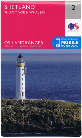 Figure 15 Landranger 2 (Feb 2016) |
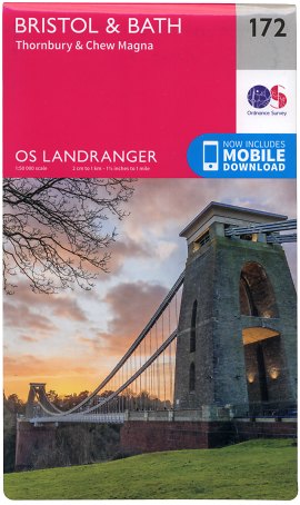 Figure 16 Landranger 172 (Feb 2016) |
On 9 February 2015 Ordnance Survey revealed a new brand identity. A photography competition was launched by OS on the same day to invite members of the public to submit photographs for use on its range of map covers. Over several stages the ‘OS Photofit’ competition saw photographs chosen for the Explorer and Tour covers. After the closing date of 31 October 2015 those photographs remaining unpicked were whittled down to 204 for use on the rebranded ‘Landranger’ covers. The full set of rebranded Landranger maps were published en masse on 24 February 2016. (Figures 15, 16)
As with the 1:25 000 Explorer maps, the rebranded Landrangers also now feature a scratch-off panel on the inside cover concealing a code which can be used to redeem a downloadable version of the map sheet.
Conclusion
The Landranger series is the dependable workhorse of Ordnance Survey’s Leisure Map range. The many specification changes during its four decades in existence have led to a large amount of information being crammed on to each sheet, making some sheets appear rather confusing. However the Landranger still remains a hugely popular product across all sections of the British public, who have become familiar with its bright pink exterior.
Further reading on Landranger Covers
Lez Watson’s detailed study of Landranger cover variants is worth a read - you can find it here.
Page last updated: 18 September 2016