1994-1997: Origins
Following the successful publication of the double-sized Gower Pathfinder (1:25 000 Second Series) sheet in 1992, Ordnance Survey decided to create a new selective-coverage 1:25 000 series of popular tourist areas across Great Britain, to complement the Outdoor Leisure series at the same scale.
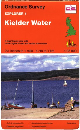 Figure 1 Explorer sheet 1 (Mar 1994) |
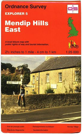 Figure 2 Explorer sheet 5 (Mar 1994) |
Thus the ‘Explorer’ series was launched in March 1994 with the publication of sheets 1 to 5. These sheets were mainly constructed from exact combinations of 1:25 000 Second Series sheets (the one exception being sheet 2 Chiltern Hills North which was a combination of two full sheets and two half-sheets), incorporating minor revisions and using the same simple colour scheme. Sheet 3 Chiltern Hills South was the only double-sided sheet of the five.
The Explorers’ covers followed the style of the time, with a cover photo, sheet title in white and the Ordnance Survey logo in a box. The orange colour distinguished the Explorers from the other series with similar covers. (Figures 1, 2). Their Pathfinder origins are belied by the fact that there is no legend information printed on the maps themselves; the legend panel takes up the entire inside cover instead. This allowed the use of a cover just 222mm (8¾in) tall - almost a quarter-inch shorter than the 1:50 000 Landranger series covers.
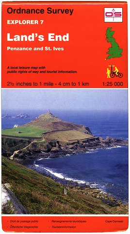 Figure 3 Explorer sheet 7 (Apr 1995) |
 Figure 4 Explorer sheet 15 (May 1996) |
 Figure 5 Explorer sheet 31 (Mar 1997) |
Having had time to judge the success of the initial five sheets, Ordnance Survey set out on the publication of a further 26 sheets from April 1995 onwards. These later sheets used more complex sheet lines not necessarily coinciding exactly with combinations of 1:25 000 Second Series sheets. Explorer sheets 6 to 31 also employed full-colour printing, making differing types of roads a great deal easier to identify: motorways (and waterways) in blue, A-roads in red, B-roads in orange, unclassified roads in yellow or uncoloured, and forests & rights of way in green (i.e. much the same colour scheme as the Outdoor Leisure series). They were also issued in covers that were 240mm (c. 9½in) tall - some 18mm (c. ¾in) taller than Explorer sheets 1 to 5. (Figure 3)
In 1996 the Ordnance Survey logo was redesigned. The first published map to carry the new logo and the new ‘house style’ was Explorer sheet 15 Rutland Water, published in May 1996. (Figure 4). The last of the 31 Explorer sheets was published the following Spring. (Figure 5). A list of the original 31 Explorer sheets can be found here.
It was clear by now that the series had become a success, but the Explorer was about to be led into new territory.
1997-1998: Exploring new areas
A great deal had changed in the three decades since the 1:25 000 Second Series maps first appeared, and the increased emphasis on both marketing and efficiency led Ordnance Survey to consider replacing the Second Series with a series which had fewer individual sheets. The decision was taken late in 1996 that the Explorer series should form the basis of a new national-coverage 1:25 000 map series, for all areas of the country not already covered by the Outdoor Leisure series.
The layout of the national Explorer series was constructed largely using geographically-based sheet lines where possible, instead of purely grid-based sheet lines, i.e. for the most part not allowing important features/towns to be spread over more than one sheet. This was designed to make the Explorer series more user-friendly and therefore hopefully more popular than the previous national 1:25 000 series.
The 370 Explorer sheets are numbered (slightly haphazardly) from south-west to north-east, the first sheet being no. 101 Isles of Scilly. The sheet lines are not regular, and the area that each sheet covers is not uniform, though generally a single-sided Explorer sheet covers approximately 600km² - 650km². 144 of the 370 sheets in the series are double-sided, each covering an area of up to approx. 860km².
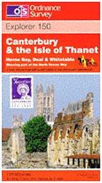 Figure 6 Explorer sheet 150 (May 1997) Picture from Blackwell’s Online |
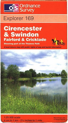 Figure 7 Explorer sheet 169 (Jun 1998) |
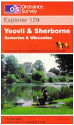 Figure 8 Explorer Sheet 129 (Sep 1997) Picture from Blackwell’s Online |
Sheet 150 Canterbury & the Isle of Thanet was the first of the extended series to be published, in May 1997. (Figure 6). The extension of the series meant that the original Explorer sheets (nos. 1 to 31) had to be re-numbered and, in some cases, their sheet lines were re-cast. In fact in July 1997 Explorer sheet 1 Kielder Water was replaced by a sheet in the 1:25 000 Outdoor Leisure series covering a much larger area. The re-jigging of the orignal Explorer sheets took place over the following four years, concurrent with the rapid publication of new Explorer sheets. (Figure 7). Digital scanning of the source material (taken from the 1:25 000 Second Series) and extensive digital revision were among the techniques employed to ensure publication of new sheets at a much faster rate than would have previously been possible. It was to be 2003, however, before the series was complete.
The 144 double-sided Explorer sheets all have shorter covers than the rest of the series: they are 227mm (c. 9in) tall (identical to the Landrangers) instead of the regular 240mm (c. 9½in). The first of these to be published was sheet 129 Yeovil & Sherborne in September 1997; more soon followed. (Figure 8)
1998-2003: Celebration, consolidation, completion
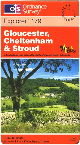 Figure 9 Explorer sheet 179 (Dec 1999) with Millennium Products logo |
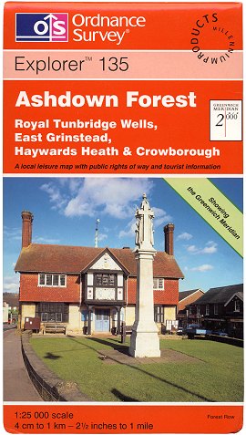 Figure 10 Explorer sheet 135 (Jun 1999) Showing the Greenwich Meridian |
 Figure 11 Explorer sheet OL45 (Mar 2002) Formerly Outdoor Leisure 45 |
The Explorer series was awarded the ‘Millennium Products’ accolade by the Design Council on 2 April 1998, in recognition of its innovation and that it enabled “many more people to discover and enjoy Britain’s natural and cultural environment.” Ordnance Survey used the ‘Millennium Products’ logo on the covers of the Explorer series from late 1998 to mid 2001. (Figure 9)
As the start of the new millennium approached, Ordnance Survey decided to ‘cash in’ on the hype. The Greenwich Meridian (0° longitude) was seen as the focus for celebrations, being the point from which global longitude and time of day is measured. Between January and July 1999, the seventeen Explorer sheets crossed by the Greenwich Meridian were published with the addition of a thick green line across the map face representing the line of 0° longitude. The covers of the maps indicated this by way of a green flash with the words “Showing the Greenwich Meridian”. (Figure 10). For details of the sheets involved, see the themed category page here.
While the 1:25 000 Outdoor Leisure series had existed quite happily in its own right for three decades, in time it was realised that having two separate 1:25 000 series covering Great Britain was not an ideal situation. The decision was taken, therefore, that the Outdoor Leisure maps should become part of the Explorer series. The resulting 33 ‘Explorer OL’ sheets - first published on 4 March 2002 - carry their original numbers from the Outdoor Leisure series but with an ‘OL’ prefix. (Figure 11). All the sheets in the ‘OL’ range of Explorer maps are double-sided, covering an area of up to 1,300km² each and appearing in the regular 240mm (c. 9½in) tall cover. This increased to 177 the number of double-sided sheets in the Explorer series overall. For a couple of years following the amalgamation of the Explorer and Outdoor Leisure series, a yellow flash on the front cover of the Explorer OL maps explained that they were formerly Outdoor Leisure sheets. A similar explanatory note was also to be found on the rear-cover sheet indexes of some Explorer maps.
March 2002 saw the launch of Ordnance Survey’s ‘Free Maps for 11-year olds’ scheme: every pupil in Year 7 (England/Wales) or Primary 7 (Scotland) was eligible to receive a free copy of their local Explorer map. In excess of five million Explorer maps were provided free of charge to pupils through the scheme until its closure in 2010.
The publication of the Explorer series - and thus the replacement of the 1:25 000 Second Series - was completed on 12 March 2003 with the publication of the final ten sheets (nos. 461-470) covering Orkney and Shetland.
Interlude: Design changes on Explorer covers 1996-2006
Many changes - subtle or otherwise - were applied to the design of the Explorer cover between 1996 and 2006. The main changes concern the top of the front cover, and are best illustrated using actual examples. Thus, the pictures and text below detail the known stages of change and their approximate production dates.
 May 1996 - Late 1998 The first design with the new Ordnance Survey logo |  Late 1998 - Early 1999 The cover now carries the ‘Millennium Products’ accolade |  Early - Mid 1999 The Ordnance Survey logo gains a ® symbol |  Mid 1999 - Mid 2000 The ‘Explorer’ name gains a ™ symbol |
 Mid 2000 The OS web address is rather crudely shoe-horned in |  Mid 2000 - Mid 2001 The OS logo and web address are reduced in size |  Mid 2001 - Mid 2003 The ‘Millennium Products’ logo is no longer used |  Mid 2003 - Mid 2006 The web address is removed; the OS logo is unchanged |
2004-2008: Outdoor activities
The Countryside and Rights of Way Act 2000 legislated new powers for the public to roam on areas of so-called ‘Access Land’. These rights came into effect between September 2004 and December 2005, in stages, in nine regions of England and Wales. Ordnance Survey, as the national mapping agency, was given the task of detailing the extent of these areas of Access Land on their maps, and chose the Explorer for the task.
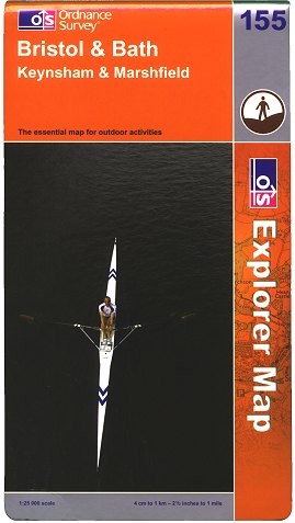 Figure 12 Explorer sheet 155 (Nov 2004) |
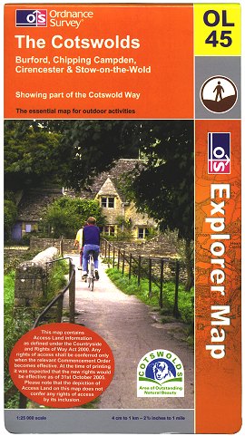 Figure 13 Explorer sheet OL45 (Oct 2005) |
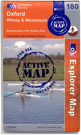 Figure 14 Explorer sheet 180 ‘Active’ edition (Mar 2006) |
As each area gained its access rights Ordnance Survey planned to publish the relevant revised sheets, rebranded as ‘OS Explorer’ maps in a new-style cover based on the 2002 house style. (Figures 12, 13). The photographs on the revised covers are no longer necessarily of a particular place on the map: a note inside explains that the cover photo merely illustrates the type of activity and/or landscape that can be found in the area the sheet covers.
In the event, after initially keeping up, the publication schedule began to fall slightly behind the official roll-out of Access Land areas. Publication of the ‘Access Land’ Explorer sheets for England and Wales was finally completed in April 2006. Publication of revised sheets for Scotland in the updated style, but without Access Land information, was completed in December 2007.
Ordnance Survey had been wary of weatherproof maps after several unsuccessful attempts in the 20th century. As a result from the 1990s onwards several companies created and marketed their own laminated versions of OS maps, e.g. ‘TuffMap’ and ‘Aqua3’. Wanting a slice of the action, Ordnance Survey decided to have another go and in 2006 created weatherproof ‘Active Map’ versions of the entire Explorer series. The cover and map are laminated and the map is more durable than the standard paper version. The first batch of 180 ‘Active Map’ Explorer sheets were published in March 2006, the remaining 223 being published in November of the same year. (Figure 14). They are kept up to date with each revision of the standard format version of each sheet.
2009-2011: Pressing issues
 Figure 15 Cover spines of Explorer sheet 170 Top: 2006 (standard white lettering) Bottom: 2009 (erroneous blue lettering) |
During January and February 2009, the covers of a small number of Explorer sheets were erroneously printed with blue lettering on the Ordnance Survey logo on the spine. (Figure 15). To date, cover printings of six short-cover format Explorer sheets are known to have been affected. This was due to a design error: instructions for changing the colour of the logo on Travel Map - Tour covers were apparently misinterpreted. The error also affected several sheets of the 1:50 000 Landranger Series, but rather than scrapping all the affected covers and reprinting them, Ordnance Survey decided to let the stock sell through. Details of the sheets involved can be found here.
Late 2009 saw a review of efficiency by Ordnance Survey which led to several changes in map publication policy. One of these policy changes came into effect from March 2010: new editions of OS maps are no longer routinely given a new cover photograph or a new ISBN. Exceptions can be made where there is a significant change to the publication or when it is deemed otherwise appropriate.
Ordnance Survey’s move to newly-built premises in Southampton, planned for late 2010, meant that it would no longer be able to print its own maps in-house as there would be no room for the printing presses. It put the contract for printing its maps out to tender in November 2009 and subsequently awarded it to Butler Tanner & Dennis of Frome, Somerset on 2 September 2010. As BT&D did not possess folding or casing machines suitable for OS’s maps, OS agreed to sell its specialist equipment to the company as part of the contract.
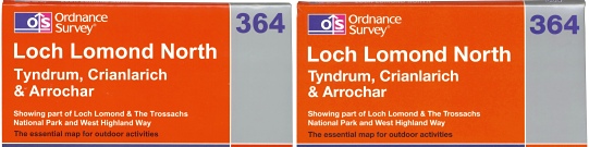 Figure 16 Covers of Explorer sheet 364 Left: c.2008 (Arial lettering) Right: Oct 2010 (Helvetica lettering) |
In early 2010 Ordnance Survey’s standard typeface had changed from Arial to Helvetica and the revised typography first appeared on ‘Travel Map - Tour’ covers from March 2010 as they were re-issued without sheet numbers. Preparation for the outsourcing of map printing, however, meant that new master templates had to be created for OS’s other maps; Explorer covers set in Helvetica appeared from September 2010. (Figure 16)
A partial transfer of equipment was undertaken such that from 14 October 2010 Butler Tanner & Dennis were able to begin printing Ordnance Survey maps while the remainder of the equipment continued to be used by OS to print in tandem, minimising disruption to map stock supply. Seven weeks later, on 1 December 2010, the printing presses at Ordnance Survey’s Romsey Road site stopped rolling, and BT&D took over the printing operation completely.
Maps and covers printed by BT&D began to appear from January 2011 onwards, but carry no overt indication of the new printer. It is possible to determine where a map or cover was printed, however, by virtue of the fact that BT&D’s half-toning is finer by comparison than OS’s. In addition, covers printed by BT&D carry Ordnance Survey’s new address at Adanac Park and also carry shading of sheet overlaps on the rear cover indexes.
2015: Rebranding
On 9 February 2015 Ordnance Survey revealed a new brand identity. The ‘OS Photofit’ competition was launched by OS on the same day to invite members of the public to submit photographs for use on its Explorer, Landranger and Tour map covers.
Three days after the rebranding exercise OS reported that paper map sales had in 2014 reversed their decline of recent years, revealing an increase in sales for the calendar year of some 3% on those of 2013. In the same press release, Explorer OL17 Snowdon was revealed as the best-selling sheet in the Explorer range.
The updated OS Publication Report on 12 March 2015 confirmed that the ‘OL’ branding was to be extended to 29 more sheets of the Explorer range; it showed that Explorer sheets 110, 119-123, 132-134, 347, 363-365, 368, 378, 386-388, 393-395, 401-405 and 418-420 would be replaced by new 'Explorer OL' sheets. The Publication Report also announced a price rise for the rebranded sheets to £8.99.
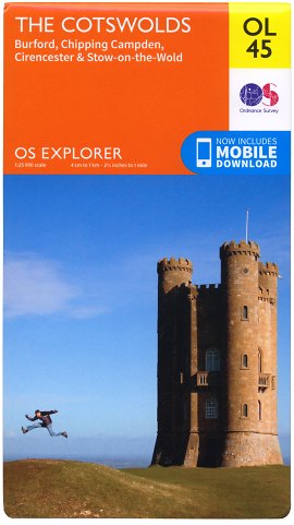 Figure 17 Explorer sheet OL45 (Jun 2015) |
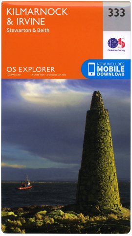 Figure 18 Explorer sheet 333 (Sep 2015) |
The first winning photographs in the OS Photofit competition - those for the 62 sheets in the extended 'Explorer OL' range - were chosen on 10 March 2015 by a judging panel including wildlife expert and photographer Simon King. The winners were announced on 18 March 2015 and in early April 2015 the completed covers began to appear on booksellers’ websites.
An OS press release on 20 May 2015 revealed that the new maps would each come with an additional 'mobile download' version of the sheet. Publication of the new 'Explorer OL' sheets took place on 10 June 2015 (Figure 17), with a new mobile app for iOS and Android devices released on the same day. The new paper maps feature a scratch-off panel inside the cover concealing a code which can be used on the OS website to redeem the downloadable version of the map.
The closing date for the second stage of the OS Photofit competition, choosing images for the covers of the remainder of the Explorer maps, was 19 April 2015. Judging took place over the following two weeks or so, with guest judge Steve McEntee from OS's retail partner WHSmith taking part. The winners were announced on 29 May 2015 and at this stage it became clear that the numbering of the standard Explorer sheets was to remain unchanged, leading to gaps in the numbering where some sheets had been 'converted' to 'Explorer OL' sheets. The completed covers for the 341 rebranded standard Explorer sheets began to appear on booksellers' websites from around 23 June 2015 and they were published en masse on 16 September 2015. (Figure 18)
Conclusion
The Explorer series has grown rapidly in popularity to become an invaluable accompaniment to walking and other countryside activities. The mapping is not subject to full systematic revision however - rather major changes are added ‘ad-hoc’ - thus Explorer mapping of rural areas can be somewhat out-of-date. Nevertheless it is the most detailed topographic map series available covering the whole of Great Britain.
Page last updated: 18 September 2016